Low-cost RTK GPS receiver (centimeter level precision) with open source software and board design targeted at UAVs.
What is RTK?
A regular GPS receiver, like you have in your cell phone, gives positions that are accurate to within a few meters. An RTK (Real Time Kinematic) GPS system gives positions that are 100 times more accurate - down to single centimeters.
What is Piksi?
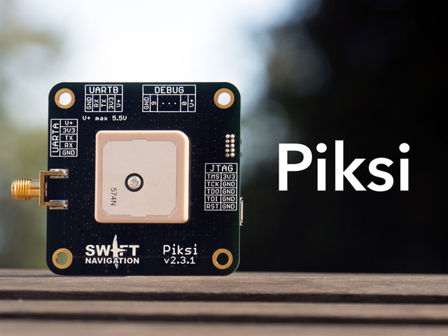
Piksi is an RTK GPS receiver with open source software that costs one tenth [1] the price of any other available RTK system.
We designed Piksi with the belief that providing this level of positioning precision at a radically lower cost would open it up to a much wider range of applications. We are particularly excited about its use in autonomous vehicle systems. Civilian and hobbyist use of UAVs has increased dramatically over the last few years, yet highly accurate, low cost localization solutions are not available yet. We hope that Piksi will help to fill this gap and push the envelope of what is possible with these systems.
Some possible applications:
UAVs
Amateur rocketry
Autonomous cars
Construction measurements
Surveying
Heading and attitude determination
GPS education
Reception of new constellations (Galileo, GLONASS, Compass, etc.)
Geo-referencing of aerial photography
Autonomous lawn-mowers
Piksi Technical Specs:
Centimeter level positioning (RTK)
Fast (50 Hz) position/velocity/time updates
Open source software and board design
Low power consumption : 500mW / 100mA typical
Small form factor : 53 x 53 mm
Low cost : $900 for a complete RTK system
For full technical specifications, check out the Piksi datasheet. User guides, code documentation, software and hardware repositories, and CAD models are all available on the Documentation Wiki.
A flexible platform
From the start, we wanted Piksi to be an indispensable tool for GPS experimentation. Whether you want to test out a new algorithm, receive signals from new constellations, more closely integrate and tune your receiver for your application, or teach yourself about GPS, Piksi gives you the flexibility, power, and transparency to do it.
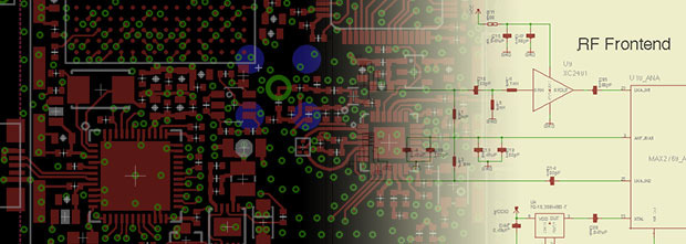
PCB Layout and Schematics are available in Eagle format.
The software that runs on Piksi is open source, as are the PCB schematics and layout. The development toolchain is supported on Linux, Windows, and OSX.
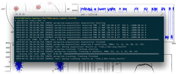
Screenshot of Peregrine - Swift Navigation's GPS post-processing software.
We’ve also developed an open source GPS post-processing tool, Peregrine, that provides a high-level interface to the same open source GPS library as used by the Piksi firmware. Raw GPS samples can be passed through Piksi over USB to a PC and post-processed with Peregrine. Being written in Python, Peregrine is well-suited for rapid development of new algorithms that can then be quickly transitioned to running standalone on the Piksi hardware.
How does RTK work?
GPS receiver measuring the distances to four satellites: the minimum number for a position fix.
A GPS receiver determines its position by measuring its distance to four or more GPS satellites. By comparing the relative phase offsets of unique 'codes' continually transmitted by the satellites, the receiver can determine the relative distance to each satellite. Each bit of the codes is about 300 meters in length, which in practice limits the precision to which the receiver can measure the code phase to a few meters. This is one reason that a normal receiver cannot achieve centimeter level accuracy.
The ionosphere slows GPS signals, a source of error that RTK systems mitigate.
Another important source of error for GPS receivers is ionospheric delay. When GPS signals travel through the ionosphere, they are slowed, adding a few meters of error to the distance measurement. The amount the signal is slowed varies over time and location, and is difficult to predict.
An RTK GPS receiver achieves centimeter level accuracy by mitigating these two sources of error.
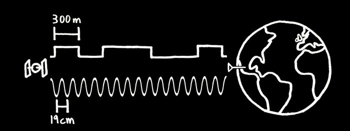
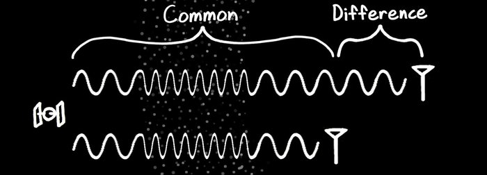
RTK receivers measure the phase of the carrier wave (bottom) for greater precision.
First, in addition to measuring the code phase, an RTK GPS receiver measures the phase of the carrier wave that the code is modulated upon. The carrier has a wavelength of about 19 centimeters. This makes it possible to measure to a much greater degree of accuracy than the 300 meter code, but there is a catch - there are an unknown number of whole carrier wavelengths between the satellite and receiver. Clever algorithms are required to resolve this "integer ambiguity" by checking that the code and carrier phase measurements lead to a consistent position solution as the satellites move and the geometry of the problem changes.
Cancellation of the common ionospheric error allows computation of the relative receiver position to a high degree of accuracy.
Second, an RTK GPS receiver is able to reduce the ionospheric error with the help of an additional reference receiver. The ionospheric delay varies only slowly with location, so with a nearby reference receiver, the delay is almost the same for both receivers and can largely be cancelled out. This is why an RTK GPS system uses two receivers.
Project status
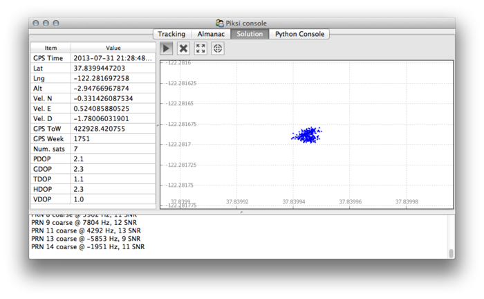
Our GUI console showing position solutions in real time.
We currently have 25 pre-production Piksi receivers (identical to the production ones) assembled and ready to ship. The Piksi firmware currently supports the functionality of a normal GPS receiver, without RTK, and we've started the implementing the RTK functionality. We've also written a host of PC-side development tools to make it easy to interact with the hardware. The development toolchain is supported on Linux, Windows, and OSX.
We’ll use the Kickstarter funding to pay for development costs that we incur while finishing the RTK functionality. We’ll also be refining the development tools and adding more documentation to make using Piksi a delight for developers and end users of any background.
Estimated Schedule
Our estimated production and delivery timeline.
Please note that whilst these are our best estimates, as with all development projects there is always going to be some uncertainty in delivery dates and the possibility for unforeseen problems and delays.
Rewards
We are offering two main rewards, the PIKSI and the RTK KIT. The PIKSI is simply a single Piksi receiver for people who only need one receiver. As we explained in our technical section above you need two receivers to do RTK so the PIKSI reward on its own won't allow you to get centimeter level precision.
The RTK KIT reward is the main deal. It contains two Piksi receivers and everything else you need to do centimeter level RTK positioning. Have a look at this diagram which shows how it all fits together:
Diagram of the Piksi RTK System : One Piksi on the ground as a reference receiver, sending ranging corrections to a Piksi onboard a UAV.
We are offering two versions of our PIKSI and RTK KIT rewards. The Developer Edition and the Production Edition. These two versions both contain identical hardware.
The difference is that the Developer Edition rewards will be shipped from the small batch of Piksi receivers that we already have assembled and will ship immediately after the Kickstarter campaign ends. Please be aware that Developer Edition rewards will ship before the RTK software development is complete.
We will be starting a new full production run of hardware for the Production Edition rewards which will be ready to ship in December when the RTK software development is complete.
PIKSI rewards include:
1 Piksi
1 Swift Navigation retractable Micro-USB cable
2 cable assemblies for connecting devices to Piksi’s UART headers
RTK KIT rewards include:
2 Piksi receivers
2 Swift Navigation retractable Micro-USB cables
4 cable assemblies for connecting devices to the Piksi UART headers
2 XBee radios
2 cable assemblies for connecting the XBee radios to the Piksi receivers
Who are Swift Navigation?
The Swift Navigation team: Colin Beighley and Fergus Noble
We previously worked at a company named Joby Energy where we successfully developed an RTK GPS system for high-altitude wind turbines. This system was used to guide UAV’s in highly dynamic environments (greater than 8g accelerations, over 100mph). We've both been working on GPS full time for the past 2-3 years, and were working on our own independent GPS projects before that. See our Kickstarter bio for more information. And for those interested, here’s a presentation we gave at Defcon 2012 on GPS.
Risks and challenges!
We have already built a small batch of Piksi receivers that are ready to ship and have locked down all part sourcing and manufacturing for further batches, so there are unlikely to be any unanticipated delays in the delivery of Piksi hardware.
However, it’s difficult to know exactly how long the RTK functionality will take to implement - software development schedules seem to always run over their anticipated delivery dates, even when you take into account Hofstadter's Law. We feel the goals we’re proposing to accomplish with this campaign are reasonable - adding a new set of software functionality (which we successfully implemented on a previous platform) upon an existing base of stable hardware and software.
We’ve planned out the development schedule with these facts in mind, giving ourselves enough time to have the new features finished by the delivery date.
Piksi GPS On An Octorotor The Piksi is the little square with wires. Swift Navigation
GPS is really good at finding where people are, typically with a margin of error of just a few meters. That's fine if you're using GPS for driving directions, but if you're, say, a drone operator, you might want to navigate the sky more precisely, as a few feet can mean the difference between flying between buildings and crashing into them. Created by Swift Navigation, the Piksi (pronounced "pixie") GPS receiver could give unmanned aerial vehicles a GPS signal accurate to an inch. The project has already received nearly six times its initial funding goal on Kickstarter.
Fergus Noble and Colin Beighley, the guys behind Swift Navigation, have experience in drones, specifically with work on wind turbines attached to flying kites. Knowing the precise location of a kite as it flies in circles is important, because the kite will fly autonomously for months and needs to self-correct back to a designated course in case anything sends it off-track. Knowing precisely where it is within inches is much better than being off by several feet. This was an especially acute need with some small prototypes flying in circles not much bigger than regular GPS margin of error.
Unfortunately, the available technology to track such kites is super expensive. For example, the trade publication GPS World names the Sokkia GRX2 as a low-cost possibility, and it costs $14,500. That might be low cost for the Pentagon or Exxon Mobil, but for most everyone else it's a little pricey. Faced with that, Noble and Beighley set out to create their own version.
Diagram of the Piksi RTK System :So the TIE fighter attacks the helicarrier with WiFi? "One Piksi on the ground as a reference receiver, sending ranging corrections to a Piksi onboard a UAV." Oh. Swift Navigation
The Piksi is a Real-Time Kinematic (RTK) GPS receiver, best explained in reverse. The receiver part means it gets signals from satellites in Earth's orbit. These satellites transmit a signal of their own location in orbit, with a time signature, down to Earth. A receiver uses the signals from four or more satellites to pinpoint a spot on Earth. Wherever the signals overlap on Earth, that's where the receiver is, and this makes the GPS system. However, the size of the waves transmitting the signal mean that the spot of overlap is several feet.
RTK works from a disparity in the length of the code transmitted and the length of the wave carrying the signal. The signal itself travels in a wave, with the location information coded in segments 985 feet long. The waves making up that code are much smaller than the whole code, with each wave about 7.5 inches from peak to peak.
Piksi uses this information to create a more precise measurement. In communication with another RTK receiver for reference, the RTK GPS system, like one in use on a drone, compares the difference in number of wavelengths between the reference point and the system itself. Since the reference point is a known location, this cross-checking of wavelengths, combined with clever algorithms, lets the RTK receiver pin the location down to within inches.
To make this clever system available at just $900, the Piksi uses open-source software and a two-receiver check system. Cheaper, commercially available processors also help bring costs down. Noble also tells Popular Science that another reason for high competitor costs is simply "that the market can bear it." With the billion-dollar budgets of oil companies and military clients, prices in the thousands of dollars are hardly notable.
For real-world applications, imagine a crop-dusting robot that flies low and precisely over every single row of corn, or a small drone that carries packages from rooftop to rooftop with the precision of a carrier pigeon.